|
One Ecosystem : Software Description
|
|
Corresponding author: Steffen Reichel (steffen.reichel@sbg.ac.at)
Academic editor: Benjamin Burkhard
Received: 05 Apr 2018 | Accepted: 24 Sep 2018 | Published: 15 Oct 2018
© 2018 Steffen Reichel, Hermann Klug
This is an open access article distributed under the terms of the Creative Commons Attribution License (CC BY 4.0), which permits unrestricted use, distribution, and reproduction in any medium, provided the original author and source are credited.
Citation: Reichel S, Klug H (2018) An online method database for mapping and assessing ecosystem services. One Ecosystem 3: e25542. https://doi.org/10.3897/oneeco.3.e25542
|
|
Abstract
Background
Since the foundation of the ecosystem services concept in the ninetieth of the last century (
New information
Going beyond the previously mentioned challenges requires a flexible methodology for assessing and mapping ecosystem services. The Horizon 2020 project ESMERALDA (Enhancing ecoSysteM sERvices mApping for poLicy and Decision mAking) developed this methodology and implemented it into the "MAES explorer"*
Keywords
MAES; methods; case studies; policy questions; business questions
Introduction
The ESMERALDA project supports European member states and affiliated countries in fulfilling their obligations in relation to the European Biodiversity Strategy, in particular Target 2 and Action 5 "Mapping and Assessment of Ecosystems and their Services" (MAES)(
The overall objective of this database and the resulting MME tool is to support the selection of appropriate methods or combination of methods to carry out mapping and assessment of ES, depending on local to regional preconditions. These preconditions for selection can be data and time requirements, expertise, knowledge and experience or the purposes of investigation (e.g. specific policy questions). Another objective is to share experiences through co-creation of knowledge and promotion of an active dialogue via social media and active user groups, like that implemented in OPPLA*
This open access tool connects different policy domains and policy/business objectives and has the potential to be interlinked with the MAES explorer*
Project description
The ESMERALDA project specifically focuses on ecosystem services assessments and mappings within European member states but is not limited to them. Literature searches predominantly happened with a focus on European study areas and description of those in literature. However, references also include outer European territories and references and related methods used within them.
To ensure a seamless and independent public access of information about literature, methods and case study areas dealing with ecosystem services, a web-based platform has been chosen by the ESMERALDA consortium members. The process of the creation of the underlying database is explained in
Search filters implemented by the webtool.
|
Filter |
Description |
|
Business / policy domain |
The business / policy domain that is covered by the study. |
|
Country |
The country / countries covered by the study. |
|
Dimension (Domain) |
The Domain of the method used (biophysical, economic or social). |
|
Ecosystem service class |
The ecosystem service that was mapped / assessed. |
|
Ecosystem type |
The ecosystem type that was mapped / assessed. |
|
Method |
The method(s) used to map / assess. |
|
Scale mapped / assessed |
The scale of the assessment / mapping (local, regional, national, multinational). |
|
Tier applied |
The tier that was applied. |
To enable a method-centred view on the reviewed literature and the case studies, underlying references are cross-linked with an additional document – the "method compendium" – described in
Datamodel
While the data collection method and content of the database is described in detail in
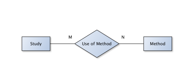
The normalisation process resulted in three basic entities:
- Study: Representing a case study with their referenced literature items and basic metadata like authors, year, title, DOI etc.
- Method: A particular method from the method compendium (
Santos-Martin et al. 2018 ), described with additional metadata such as domain (biophysical, economic, social). - Use of method: This constitutes the M:N relationship of methods and studies, containing attributes like ecosystem service assessed, tier, scale etc.
Moreover the dataset was further normalised by creating look-up tables on additional parameters – such as ecosystem types or ecosystem services. Finally, the spreadsheet document was imported into a SQL database for web-enabling storage, data input and data retrieval.
Backend
To ensure a smooth transition of the developed tool to its final hosting platform after the ESMERALDA lifetime, no backend has been set up. Instead, the Javascript-Library 'LokiJS'*
Frontend
The frontend is based on Javascript/Typescript*
Results
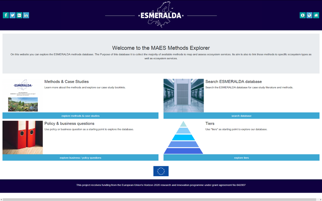
The development of a user-friendly graphical user interface (GUI) for searching ecosystem services assessments and mapping methods resulted in four main parts (Fig.
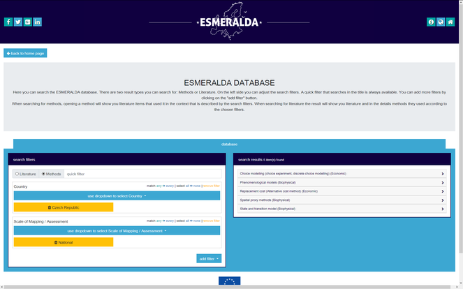
The option "Search ESMERALDA database" opens the search mask with filtering options (Fig.
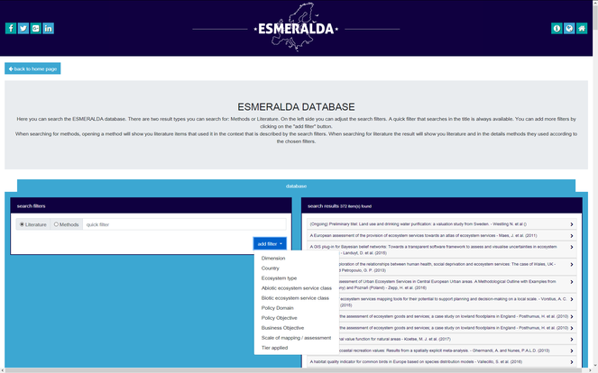
Screenshot showing the search result page. On the left, the search filters can be configured and the right column shows the entries that match the filter.
To ease the entry for new users, three further options have been pre-configured (Fig.
- Methods & Case Studies
- Policy & business questions
- Tiers
Pre-configured search parameters help integrating additional ESMERALDA products. Amongst them are case study booklets e.g. the example from Czech Republic in (Fig.
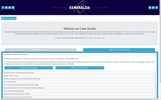
Screenshot showing the case study fact sheets that can be accessed via the tool website. From here, a pre-configured search mask, specific to the selected case-study booklet can be opened.
Similar to the implementation of sections of the tiered approach and the policy questions, these pre-configurations are realised as Uniform Resource Locator (URL) parameters to the search mask. This parameterised web-link enables a pre-defined set of searches to be exchanged (e.g. via email) to third parties.
Discussion and recommendations
With scientists, practitioners, stakeholders and policy-makers involved, ESMERALDA was able to provide a web-based framework to enable public access to resources and descriptions of ecosystem services assessments and mappings. This includes descriptions of meaningful case study area examples, a collection of 372 peer-reviewed and grey literature references. It further lists fully described methods from three domains (biophysical, economic and socio-cultural) and applications that have been used to assess and map ecosystem services. Filtering and searching is possible through pre-defined keywords, enabling a tailored view to end-users demanded methods, case studies or further readings.
In this article, we have presented a web tool that enables interested users to browse the ESMERALDA methods database online on resources for ecosystem service assessments and mappings. We demonstrated flexible search filters that provide non-experienced users with pre-configured entry points into the datasets. The MME tool is open to more entry points, without changing the web-tool itself. Thus, to leverage the full potential of the tool and the database itself, further developments could include new entry points defined by end-users. These entry points might be considered in combination with a seamless integration of other community driven portals and tools. This seamless integration would require standardised and thus compatible interfaces at both server sides and a minimum of mandatory ISO 19115 metadata standard entries (
Having developed a solid infrastructure about case studies, methods and literature, linking spatio-temporal data and metadata would be desirable as a next step to enable direct linking from a case study to its data and implementation. This should go beyond a download service as presently implemented at the Ecosystem Service Partnership Service webpage*
Presently missing is the spatio-temporal view on the database resources. Spatial map interactions going beyond the visualisation of case study maps – as, for example, outlined by
Altogether, these recommendations could lead to a European Ecosystem Service Portal, where standardised web services are connected according to the role model from
Outlook
Decoupled spatial resources should be streamlined into an "Automated Geosynthesis", where Geosynthesis is committed to the combination of spatio-temporal components or elements on the Earth (e.g. soil, geology, water) to form an interconnected whole. Considering the sum as an entity greater than the amount of its single elements, the Geosynthesis should provide spatio-temporal improvements in the understanding of the processes and functions operating in landscapes in order to derive ecosystem services out of them. This refers not necessarily to environmental parameters only but also includes social and economic properties. Thus, in future, the focus should be not looking at one particular method but a combination of methods to be used for analyses. Once the methods provided in MMA become operational via web interfaces, the Automated Geosynthesis should deliver on-demand operational (web-)services and products that assemble publicly accessible geo-spatial information and ecosystem services methods from distributed Spatial Data Infrastructures (SDI) for complex analysis. Results should enhance and support the qualified decision-making process in a more efficient and effective way as manual desktop based assessments. Scattered spatio-temporal information is expected to be requested at the time needed, rather than previously copying (already outdated resources) from one source to another. Requests for information retrieval can be triggered either by human or automatically by changing (raster/vector) datasets or by near real-time operational sensors analysing the present state of the environment. Compared to hard copy offline information, the internet, as a fast, efficient and effective information distribution medium, offers sufficient capabilities to provide continuously updated and 'live' information on ecosystem services (supply and demand), as, for instance, started with the Ecosystem Service Partnership map viewer*
Conclusion
Based on the state-of-the-art possibilities, the innovations achieved with the MME database are minor, but compared to the project resources available for this task are of high importance. MME could operate as a starting point for further applied research, where the application of existing standards and to be derived ecosystem services standards are getting more into focus. Nevertheless, the unique selling point of the online tool is the collection of existing studies as an essential step to find methods most suitable for mapping and assessing ecosystems in a particular region at a specific scale.
This project receives funding from the European Union's Horizon 2020 research and innovation programme under grant agreement No 642007.
Web location (URIs)
Technical specification
Usage rights
Acknowledgements
This project receives funding from the European Union's Horizon 2020 research and innovation programme under grant agreement No 642007.
References
-
Modelling vSGPs (very shallow geothermal potentials) in selected CSAs (case study areas).Energy71:226‑244. https://doi.org/10.1016/j.energy.2014.04.054
-
A pan-European planning basis for estimating the very shallow geothermal energy potentials.Renewable Energy75:335‑347. https://doi.org/10.1016/j.renene.2014.09.033
-
An online platform supporting the analysis of water adaptation measures in the Alps.Journal of Environmental Planning and Management1‑16. https://doi.org/10.1080/09640568.2017.1301251
-
Models as web services using the Open Geospatial Consortium (OGC) Web Processing Service (WPS) standard.Journal Environmental Modelling & Software41:72‑83. https://doi.org/10.1016/j.envsoft.2012.11.010
-
The value of the world's ecosystem services and natural capital.Nature387:253‑260. https://doi.org/10.1038/387253a0
-
The value of the world’s ecosystem services and natural capital.Ecologcial Economics25:3‑15. https://doi.org/10.1016/S0921-8009(98)00020-2
-
Functions of Nature. Evaluation of nature in environmental planning and decision making.Wolters-Noordhoff,Groningen.
-
A visualization and data-sharing tool for ecosystem service maps: Lessons learnt, challenges and the way forward.Ecosystem Services13:134‑140. https://doi.org/10.1016/j.ecoser.2014.12.002
-
Integrating methods for ecosystem service assessment: Experiences from real world situations.Ecosystem Services29:499‑514. https://doi.org/10.1016/j.ecoser.2017.10.014
-
Our life insurance, Our Natural Capital: An EU Biodiversity Strategy to 2020.European Commission,Brussels. URL: http://ec.europa.eu/environment/nature/biodiversity/strategy/target2/index_en.htm
-
WPS mediation: An approach to process geospatial data on different computing backends.Computers & Geosciences47:20‑33. https://doi.org/10.1016/j.cageo.2011.10.009
-
A tiered approach for mapping ecosystem services.Ecosystem Services13:16‑27. https://doi.org/10.1016/j.ecoser.2014.10.008
-
Selecting methods for ecosystem service assessment: A decision tree approach.Ecosystem Services29:481‑498. https://doi.org/10.1016/j.ecoser.2017.09.016
-
19115-1 - Geographic information -- Metadata.ISO,140pp.
-
Handling a messy world: Lessons learned when trying to make the ecosystem services concept operational.Ecosystem Services29:415‑427. https://doi.org/10.1016/j.ecoser.2017.08.001
-
A SMART Groundwater Portal: An OGC web services framework for hydrology to improve data access and visualisation in New Zealand.Computers and Geosciences69:78‑86. https://doi.org/10.1016/j.cageo.2014.04.016
-
A Spatial Data Infrastructure Approach for the Characterization of New Zealand's Groundwater Systems.Transactions in GIS20(4):626‑641. https://doi.org/10.1111/tgis.12171
-
Enhancing Location-Related Hydrogeological Knowledge.ISPRS International Journal of Geo-Information7(4): . https://doi.org/10.3390/ijgi7040132
-
OpenGIS Catalogue Service Implementation Specification (ISO 19115), v2.0.2.The Open Geospatial Consortium (OGC),219pp. URL: http://www.opengeospatial.org/standards/is
-
OpenGIS Web Feature Service 2.0 (ISO 19142) WFS v2.0.The Open Geospatial Consortium (OGC),253pp. URL: http://www.opengeospatial.org/standards/is
-
OGC WCS 2.0 Interface Standard - Core, v2.0.The Open Geospatial Consortium (OGC),53pp. URL: http://www.opengeospatial.org/standards/is
-
Institutional challenges in putting ecosystem service knowledge in practice.Ecosystem Services29:579‑598. https://doi.org/10.1016/j.ecoser.2017.07.019
-
Creating an operational database for Ecosystems Services Mapping and Assessment Methods.One Ecosystem3:e26719. https://doi.org/10.3897/oneeco.3.e26719