|
One Ecosystem :
Research Article
|
|
Corresponding author: Davide Geneletti (davide.geneletti@unitn.it)
Academic editor: Benjamin Burkhard
Received: 30 Mar 2018 | Accepted: 10 Jun 2018 | Published: 10 Jul 2018
© 2018 Davide Geneletti, Blal Adem Esmail, Chiara Cortinovis
This is an open access article distributed under the terms of the Creative Commons Attribution License (CC BY 4.0), which permits unrestricted use, distribution, and reproduction in any medium, provided the original author and source are credited.
Citation:
Geneletti D, Adem Esmail B, Cortinovis C (2018) Identifying representative case studies for ecosystem services mapping and assessment across Europe. One Ecosystem 3: e25382. https://doi.org/10.3897/oneeco.3.e25382
|
|
Abstract
A key task in the ESMERALDA project dealt with identifying appropriate case studies to test the 'flexible methodology' in its different stages of development. Case studies consist of working examples in which mapping and assessment of ecosystem services were applied to address specific decision-making problems. Testing is understood as an iterative process of co-learning that involves project partners and stakeholders, enabling the refinement of the 'flexible methodology' and the development of guidelines to support its application. Testing is conducted through a series of workshops in different European contexts, each addressing a different set of themes and regions.
This paper illustrates the selection of case studies for testing the ESMERALDA 'flexible methodology' in its different stages of development. Particularly, case studies had to be selected in such a way that they are representative of: (i) the variety of existing conditions across the EU, in terms of data availability, spatial scale, levels of implementation of EU 2020 targets and expertise and experience in ES mapping and assessment; (ii) the geographical regions and biomes of the entire EU, including marine areas and the outermost regions; (iii) the variety of cross-EU themes relevant for ecosystem services, such as the Common Agricultural Policy, Green Infrastructure, Natura 2000 network, forestry strategy, water policy, energy, business and industry sectors and health; (iv) the variety of policy and planning processes that can be used to mainstream ecosystem services in real-life decisions, such as spatial and land use planning, water resource management, flooding under the EU climate adaptation action, energy policy, strategic environmental assessment, protected area planning.
Keywords
Ecosystem services, ecosystem service mapping, ecosystem service mapping and assessment, biodiversity, EU Biodiversity Strategy
Introduction
The EU Biodiversity Strategy to 2020 requires all the Member States to proceed with "Mapping and Assessment of Ecosystems and their Services" as a key step for implementing the strategy. Within this framework, the ESMERALDA project is an EU-funded initiative to support the Member States in fulfilling their activities, particularly with regard to Target 2/Action 5 of the strategy. To this end, the ESMERALDA project has proposed a ‘flexible methodology’ based on a tiered approach for mapping and assessment of ecosystem services (ES), as well as for integrating different value dimensions (Burkhard et al., this issue;
A key task in the ESMERALDA project dealt with identifying appropriate case studies to test the 'flexible methodology' in its different stages of development. Case studies consist of working examples in which ES mapping and assessment were applied to address specific decision-making problems. Testing is understood as an iterative process of co-learning that involves project partners and stakeholders, enabling the refinement of the 'flexible methodology' and the development of guidelines to support its application. Testing is conducted through a series of workshops in different European contexts, each addressing a different set of themes and regions.
This paper illustrates the selection of case studies for testing the ESMERALDA 'flexible methodology' in its different stages of development. Particularly, case studies had to be selected in such a way that they are representative of:
- the variety of existing conditions across the EU, in terms of data availability, spatial scale, levels of implementation of EU 2020 targets and expertise and experience in ES mapping and assessment;
- the geographical regions and biomes of the entire EU, including marine areas and the outermost regions;
- the variety of cross-EU themes relevant for ES, such as the Common Agricultural Policy, Green Infrastructure, Natura 2000 network, forestry strategy, water policy, energy, business and industry sectors and health;
- the variety of policy and planning processes that can be used to mainstream ES in real-life decisions, such as spatial and land use planning, water resource management, flooding under the EU climate adaptation action, energy policy, strategic environmental assessment, protected area planning.
Material and methods
Defining parameters for selecting case studies
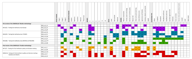
To identify case studies that meet the above-mentioned requirements of the ESMERALDA project, we first defined a set of six selection parameters, namely: A) Stage in ES mapping and assessment; B) Geographic regions; C) Biomes in EU; D) Spatial scale; E) Themes; and F) Ecosystem type. Table
|
A. Stage in ES mapping and assessment |
This refers to the status of EU Member States with regard to achieving the EU Biodiversity Strategy’s Action 5 targets for mapping and assessment of ecosystems and their services. It is based on the clustering of EU Member States according to their prerequisites and needs to perform ES mapping and assessment carried out within the ESMERALDA project (see |
|
B. Geographic regions |
This is based on the definition of regions given by the European Union's official multilingual thesaurus, which divided the EU Member States into four regions: Eastern, Northern, Southern and Western ( |
|
C. Biomes in EU |
We adopt the WWF classification of biomes, based on |
|
D. Spatial scale |
We adopt the following three spatial scales: national, sub-national and local (i.e. smaller than NUTS 3 as defined in |
|
E. Themes |
We consider the following themes as being representative for current policy challenges in the EU: Nature conservation; Climate, Water and Energy; Marine policy; Natural risk; Urban and spatial planning; Green Infrastructures; Agriculture and forestry; Business Industry and tourism; Health. |
|
F. Ecosystem type |
We adopt the classification of ecosystem types used in the MAES project: Urban; Cropland, Grassland; Woodland and Forest; Heathland and Shrub; Sparsely vegetated land; Wetlands; Rivers and Lakes; Marine inlets and Transitional waters; Coastal; Shelf; and Open ocean ( |
Selecting case studies for testing the methods
Through an online questionnaire sent to all ESMERALDA partners, we collected thirty-two potential case studies and classified them according to the selection parameters. The selection of the actual case studies was mainly driven by the specific objectives of the testing workshops, as defined in the ESMERALDA project. Moreover, for each workshop, priority was given to the case study proposed by the hosting partners, to benefit from closer interactions with diverse sets of stakeholders. Accordingly, different possible configurations that could satisfy the requirements were identified and discussed amongst the project partners to define the final list. As an outcome, we selected nine and five case studies, respectively, to test the first and the final versions of the ESMERALDA 'flexible methodology' developed within the ESMERALDA project.
Results
Overview of selected case studies
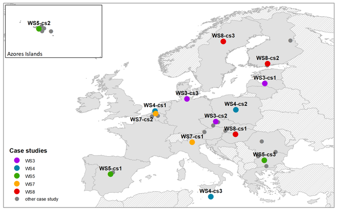
The fourteen case studies selected for testing the ESMERALDA 'flexible methodology' in its different stages of development are shown in Fig.
Case studies for testing the first version of the 'flexible methodology'
Testing the methods across Europe
The aim here was to explore whether the methods have the flexibility required for their application in a variety of geographical contexts and conditions. Accordingly, we selected case studies from Latvia, Czech Republic and Germany. These three countries represent three different stages with regard to achieving the EU Biodiversity Strategy’s Action 5 targets for mapping and assessment of ecosystems and their services (see also
Overview of the case studies selected for testing the methods across Europe. * Biomes refer to those present in the country in which the case study is located.
|
Country |
Name |
Description |
|
|
WS3-cs1 |
Latvia |
Mapping marine ecosystem services in Latvia |
The mapping and assessment of marine ES was performed as one of the steps for implementation of the ecosystem-based approach within the development of the national Maritime Spatial Plan for Latvian territorial waters and the Exclusive Economic Zone (see |
|
WS3-cs2 |
Czech Republic |
Pilot National Assessment of Ecosystem Services |
This Czech pilot ES assessment and mapping followed the worldwide mainstreaming and establishment of global and sub-global assessments within the framework of the Millennium Ecosystem Assessment to contribute to the knowledge on the state of the environment and the sustainable management of natural capital in the Czech Republic (see |
|
WS3-cs3 |
Germany |
Mapping ES dynamics in agricultural landscapes |
The case study is located in the Bornhöved Lakes District, about 30 km south of the federal state capital Kiel (see |
Testing the methods across themes
The aim here was to test the methods across themes. To this end, the selected three case studies Netherlands, Malta and Poland deal with, “Natural risk”, “Agriculture and Forestry” and "Urban and Spatial planning", respectively. While these are the main themes justifying the selection, the case studies also actually address other issues. Table
Overview of the case studies selected for testing the methods across themes. * Biomes refer to those present in the country in which the case study is located.
|
Country |
Name |
Description |
|
| WS4-cs1 | Netherlands | Ecosystem services-based coastal defence | The Haringvliet used to be the most important river mouth of the rivers Meuse and Rhine. When, in 1971, the rivers were closed from the sea by the Haringvliet dam, the rich estuarine ecosystem greatlydeteriorated. In 2018, the Dutch government will start opening the Haringvliet dam. Six large Dutch nature organisations have joined forces to optimally use this development and think beyond 2018 in order to bring back dynamics for real estuarine nature, migratory fish and birds. In this context, building on previous secondary valuation, a new primary valuation study is assessing the potential future state of the Haringvliet in terms of the relevant economic, social and environmental changes. |
| WS4-cs2 | Poland | Ecosystem services in Polish urban areas | Commissioned by the Ministry of the Environment, the study is part of the implementation of Urban MAES pilot project. The study identified the spatial structures of ecosystems in the 10 largest urbanised areas in Poland and compared them in terms of their potential for providing services. Thus, it proposed operational procedures for identifying and evaluating selected services, by demonstrating their spatial distribution in the urban areas. Importantly, the results of the study fed into key recommendations for spatial planning on local and sub-regional levels. |
| WS4-cs3 | Malta | Ecosystem service accounting in the Maltese Islands | The Maltese Islands make for an interesting model for analysis of the role of mosaic and multi-functional landscapes in the delivery of ES in densely inhabited islands in which biodiversity would be expected to be subject to substantial pressure (see |
Testing the methods across Biomes and Regions
The aim here was to test the methods addressing specific biomes and areas, including marine areas and the EU Outermost Regions. Thus, to cover different types of biomes and ecosystem, we included a case study from Spain, one from Portugal – Azores (an Outermost Region) and one from from Bulgaria. Table
Overview of the case studies selected for testing the methods across Biomes and Regions. * Biomes refer to those present in the country in which the case study is located.
|
Country |
Name |
Description |
|
| WS5-cs3 | Spain | Spanish National Ecosystem Assessment | The case study provides the first analysis at national level that evaluates the ability of the Spanish ecosystems and biodiversity to sustain human well-being. The study aims at highlighting the contribution that ecosystems and biodiversity make to human well-being, not only in ecological terms, but also in social and economic terms. It helps break down barriers and build bridges between interdisciplinary scientific knowledge and decision-making to visualise the complex relationships that exist between the conservation of ecosystems and human well-being based on empirical data. It is also increases the awareness of Spanish society, including the business sector. |
| WS5-cs2 | Portugal - Azores | BALA - Biodiversity of Arthropods from the Laursilva of Azores | This is a first assessment of ES, based on arthropod diversity, distribution and ecological data in the Azores: an oceanic isolated northern Atlantic archipelago made up of nine main islands and some small islets. This study is highly relevant in the context of several international policies such as the International Initiative for the Conservation and Sustainable Use of Pollinators, the FAO's Global Action on Pollination Services for Sustainable Agriculture and the IPBES on pollinators, pollination and food production. |
| WS5-cs3 | Bulgaria | Central Balkan National Park | The study area is located in Central Bulgaria and covers the central part of the Balkan Mountains (see |
Case studies for testing the final version of the 'flexible methodology'
Testing the final methods in policy- and decision-making (I)
The aim here was to illustrate how the final methods can be used to guide real-life policy- and decision-making across Europe and across themes. Thus, illustrative policy- and decision-making processes were selected and used to analyse how the methods are able to provide information for the different stages of the processes (including interaction witth stakeholders and decision-makers) and to promote outcomes that are more in line with the objectives of the EU Biodiversity Strategy. The selected case studies are from Italy and Beligium, both dealing with ES mapping and assessment in an urban context. Particularly, the two case studies allow the investigation into how mapping and assessment of urban ES can inform about/support different stages of the urban/spatial planning process. Table
Overview of the case studies selected for testing the final methods in policy- and decision-making. * Biomes refer to those present in the country in which the case study is located.
|
Name |
Country |
Descriptionn |
|
|
WS7_cs1 |
Italy |
ES mapping and assessment for urban planning in Trento |
The city of Trento is located in northern Italy, with a population of around 117,300 inhabitants (see |
|
WS7_cs2 |
Belgium |
Mapping green infrastructures and their ES in Antwerp |
Antwerp is the second largest city in Belgium. With 517,000 inhabitants and a surface area of 204.5 km², the city is a mix of a highly urbanised central area, with a clear shortage of available green space, some larger important conservation areas at the borders of the city and an industrial harbour area. Antwerp has an ambition to become more “green”, thus a masterplan on green and blue infrastructure was developed, focusing on five “park-regions”. The masterplan includes large-scale restoration projects (e.g. parkspoor Noord: transform former railway station to urban park; park groot Schijn: restore a green-blue corridor and connect a large nature area to the city) and small-scale initiatives such as garden streets, green facades and urban farming. Besides this citywide strategic plan, nine local green plans at district level and one for the harbour area are currently under development or planned. Establishing win-win situations for different topics simultaneously with green and blue infrastructure is a key ambition of the city and its strategy. Mapping and assessing the impacts of green infrastructure will help to achieve this. For this purpose, the city developed the Antwerp Greentool, which contains different ES maps and integrated assessment tools. The objective of the Greentool is to inspire spatial planners and city officials to take smart and green measures when developing urban locations. |
Testing the final methods in policy- and decision-making: Businesses and citizens
This workshop was also aimed at illustrating how the final methods can be used to guide real-life policy- and decision-making; however, the focus is on the application of the methods by business and citizens. Accordingly, a case study from Hungary was selected due to its focus on local business whilst also involving several other sectors (e.g. forestry, nature conservation, tourism, agriculture and water) through the socio-economic evaluation of ES. A second case study in Finland was selected because it has a strong citizen participation component and links with the business sector. Finally, a case study from Sweden was included because it addresses reindeer husbandry planning as well as natural and cultural values in territorial planning. Table
Overview of the case studies selected for testing the final methods by businesses and citizens. * Biomes refer to those present in the country in which the case study is located.
|
Country |
Name |
Description |
|
|
WS8_cs1 |
Hungary |
Fostering pro-biodiversity business in the Bukk National Park |
Bükk National Park - a part of the Northern Mountain Range of Hungary - was established in 1977 and covers 43 thousand hectares. It is mainly managed and utilised as forest (94%) and, to a smaller extent, grassland (3.4%), meadow and pasture. Almost 98% of the national park is state owned, with two forestry companies as managing organisations in charge and the remaining area is managed by the Bükk National Park Directorate. The subject of the case study, however, is the wider local socio-ecological system containing low-intensity areas of settlements, arable lands, grasslands, vineyards and orchards adjacent to the National Park territory, reflecting the significance of these land uses and the opportunities offered by them to involve business and citizens. The case study is part of the project "Ecosystem services of karst protected areas – driving force of local sustainable development (Eco Karst)", funded by the EU Territorial Cooperation Programme to promote the opportunity to use the natural heritage of protected areas as an economic development factor. The project aims to support local development based on the raised awareness and sustainable management of karst ecosystems across the Danube region, including the Bükk National Park in Hungary. Accordingly, ecosystem types are mapped, ES identified, assessed and, where applicable, economically valued and spatially visualised. The results of ES assessment will be a basic resource for the discussion on increasing pro-biodiversity business opportunities. |
|
WS8_cs2 |
Finland |
Green infrastructure and urban planning in the City of Järvenpää |
The City of Järvenpää is a compact city with tight boundaries and population around 42,000 inhabitants that makes it the fourth most densely populated city in Finland. The city has an expected population growth of over 10% by the year 2030, leading to an exceptionally strong need for infill development to provide housing for new inhabitants. The city's interest was to find the tools and criteria for valuing the sites excluded from construction (i.e. green infrustructure - GI) so that future urban planning could compress and intensify the urban structure without losing the most valuable features of the GI. The objective of this study was to evaluate the green infrastructure in the city by mapping and assessing the supply and demand of the most important ES and assess the connectivity on green infrastructure. In the case study, mapping and assessment was done in three phases concentrating on the questions of: 1) how ES related benefits provided by the green infrastructure were distributed in the area; 2) how and where the citizens use these benefits and; 3) how the ecological processes providing these services were connected. The citizen role was considered by arranging a workshop, via an online questionnaire and sending a survey to schools and kindergartens to map their perceptions related to cultural ES. |
|
WS8_cs3 |
Sweden |
Ecosystem services in northern Sweden |
The Vindelälven-Juhtatdahka river valley stretches about 450 km from the Scandinavian mountain range watershed divide to the Gulf of Bothnia marine coast. The river is the southernmost one out of four national rivers in Sweden. Before railways and roads were developed, starting in the late 1800s, the river was the main historical southeast to northwest infrastructure for humans and as the natural ecological spread and migration route for species and habitat types. In particular, the annual migration of reindeer from the mountains to the coast and back – the backbone of the traditional Sami reindeer husbandry – marks the significant value of the river. The river valley includes territories used by seven Sami communities and is within the land of Sapmi, which encompasses indigenous peoples in northern Sweden, Norway, Finland and northwest Russia. The area is rich in forest, minerals and other natural resources and rich in nature conservation values. Cultural influences date back 8,000 years. The Vindelälven-Juhtatdahka river valley area is, formally, in the candidacy process for becoming a member reserve in the UNESCO Man and Biosphere Programme. The mapping and assessment of ES have been placed in the context of planning and implementing sustainable development across a large-scale biotic transition, that display a magnitude of economic, ecological and socio-cultural gradients and that arerepresentative of northern Sweden. Here, the foci are on ES associated with forest habitats, forest management and forests in a landscape context and with the indigenous Sami culture reindeer husbandry. |
Conclusions
In this paper, we presented the process for selection of the case studies involving all the partners of the ESMERALDA consortium. This included the definition of six selection parameters (i.e. A: Stage in ES mapping and assessment; B: Geographic region; C: Biome; D: Spatial scale; E: Theme; F: Ecosystem type), the collection of available case studies from the ESMERALDA partners and, finally, the selection of the case studies to be actually used in workshops.
We identified nine and five case studies to be used, respectively, for testing the first and the final versions of the 'flexible methodology' developed within the ESMERALDA project. The selected sample covers, on the whole, all the biomes in Continental Europe, the three scales selected to classify the case studies based on their territorial extent, as well as all the themes and types of ecosystems considered. Therefore, the selected sample of case studies can be considered representative of all the conditions in which the mapping methods would be applied in the future.
Acknowledgements
The ESMERALDA project receives funding from the European Union's Horizon 2020 Research and Innovation Programme under grant agreement no. 642007
Funding program
European Union's Horizon 2020 Research and Innovation Programme
Grant title
Grant agreement no. 642007
References
- Assessing urban recreation ecosystem services through the use of geocache visitation and preference data: a case-study from an urbanised island environment.One Ecosystem3:e24490. https://doi.org/10.3897/oneeco.3.e24490
- Mapping of nutrient regulating ecosystem service supply and demand on different scales in Schleswig-Holstein, Germany.One Ecosystem3:e22509. https://doi.org/10.3897/oneeco.3.e22509
- Mapping and assessing ecosystem services to support utban planning: A case study on brownfield regeneration in Trento, Italy.One Ecosystem3:e25477. https://doi.org/10.3897/oneeco.3.e25477
- Regional policy & outermost regions. http://ec.europa.eu/regional_policy/en/policy/themes/outermost-regions/. Accessed on: 2018-2-08.
- EuroVoc 4.7 - Multilingual Thesaurus of the European Union: Europe 7206. http://eurovoc.europa.eu/drupal/?q=request&mturi=http%3A%2F%2Feurovoc.europa.eu%2F100277&language=en&view=mt&ifacelang=en. Accessed on: 2018-2-12.
- Regions in the European Union: Nomenclature of territorial units for statistics NUTS.Publications Office of the European Union,Luxembourg. [ISBN978-92-79-38657-2 ISSN] https://doi.org/10.2785/53780
- Deliverable 2.1. Clustering of EU Member States according to their prerequisites and needs to perform ES mapping and assessment.EU Horizon 2020 ESMERALDA Project, Grant agreement No. 642007
- Mapping and Assessment of Ecosystems and their Services: Indicators for ecosystem assessments under Action 5 of the EU Biodiversity Strategy to 2020.European Union Technical Report,2014-080.Publications Office of the European Union,Luxembourg,82pp. [ISBN978-92-79-36161-6] https://doi.org/10.2779/75203
- Towards integrated mapping and assessment of ecosystems and their services in Bulgaria: The Central Balkan case study.One Ecosystem3:e25428. https://doi.org/10.3897/oneeco.3.e25428
- Terrestrial Ecoregions of the World: A New Map of Life on Earth.BioScience51(11):933. https://doi.org/10.1641/0006-3568(2001)051[0933:teotwa]2.0.co;2
- Mapping and assessment of cultural ecosystem services of Latvian coastal areas.One Ecosystem3:e25499. https://doi.org/10.3897/oneeco.3.e25499
- Creating an operational database for Ecosystems Services Mapping and Assessment Methods.One Ecosystem3https://doi.org/10.3897/oneeco.3.e26719
- Methodological aspects of ecosystem service valuation at the national level.One Ecosystem3:e25508. https://doi.org/10.3897/oneeco.3.e25508
- Application of the marine ecosystem services approach in the development of the maritime spatial plan of Latvia.International Journal of Biodiversity Science, Ecosystem Services & Management13(1):398‑411. https://doi.org/10.1080/21513732.2017.1398185
- On the importance of a broad stakeholder network for developing a credible, salient and legitimate tiered approach for assessing ecosystem services.One Ecosystem3:e25470. https://doi.org/10.3897/oneeco.3.e25470